
Imachen:Titan 2009-01 ISS polar maps.jpg
Fichero orichinal (1884 × 942 píxels; grandaria d'o fichero: 510 kB; tipo MIME: image/jpeg)
Resumen
| Descripción |
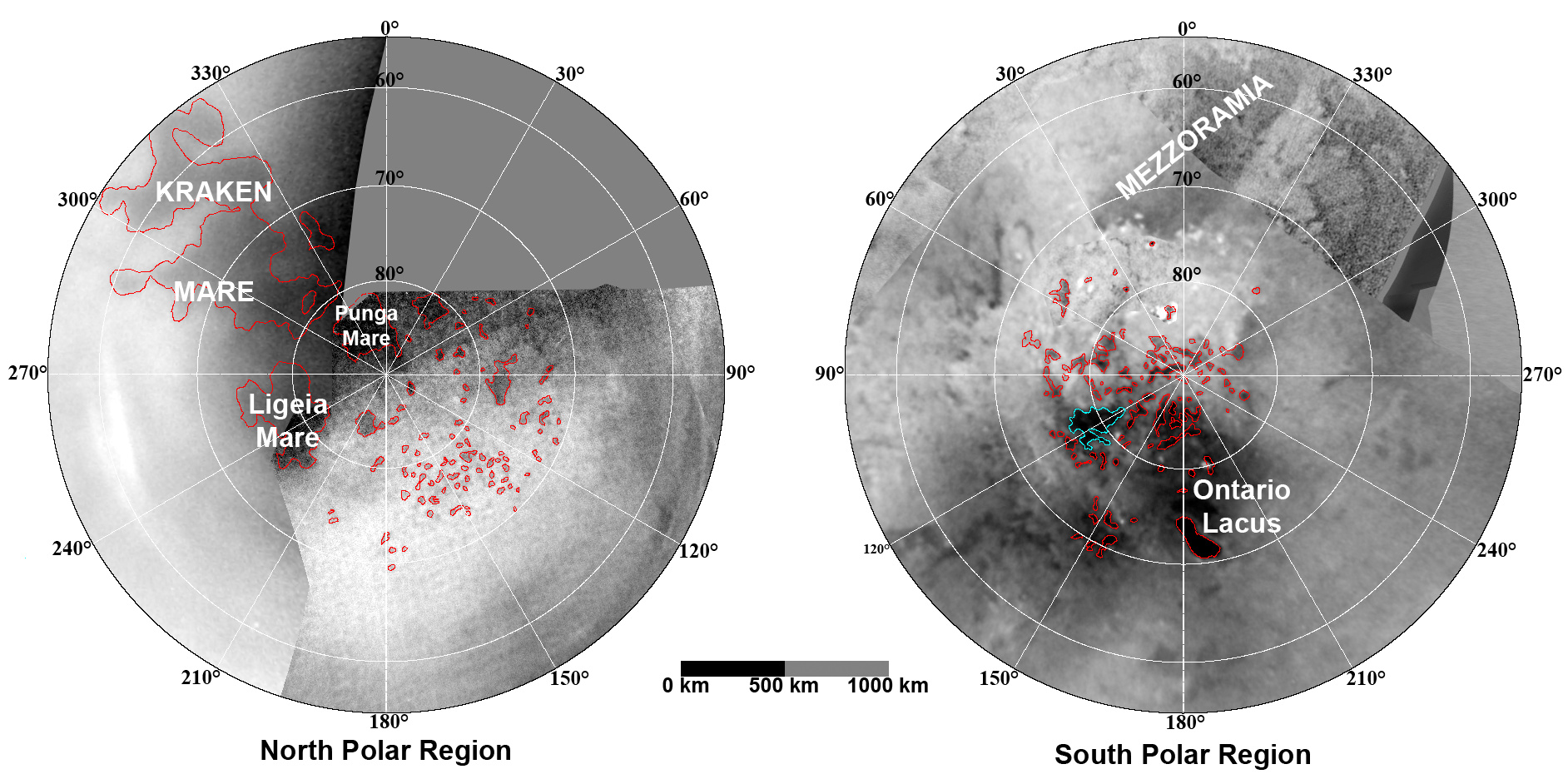
English: These updated maps of Saturn’s moon Titan, consisting of data from the Cassini Imaging Science Subsystem, include Cassini's August 2008 images of the moon's north polar region.
Evidence from Cassini's Imaging Science Subsystem, RADAR, and Visual and Infrared Mapping Spectrometer instruments strongly suggests that dark areas near the poles are lakes of liquid hydrocarbons like ethane or methane -- an analysis affirmed by images capturing changes in the lakes thought to be brought on by rainfall. Colored lines in the polar portions of these maps illustrate the boundaries between surface regions having different albedos -- or differences in surface brightness -- which Cassini scientists have interpreted as potential shorelines. Blue outlines indicate features that changed between observations made one year apart (see PIA11147). The map at left is a north polar projection showing latitudes 55 degrees to 90 degrees. The right map is a south polar projection showing latitudes minus qq55 degrees to minus 90 degrees. The maps are compiled from images dating from April 2004 through August 2008, and their resolutions vary from several hundred meters to a few tens of kilometers. Brightness variations are due to differences in surface albedo rather than topographic shading. The original NASA map of Titan has been cropped to show only the polar regions.Deutsch: Oberflächenkarte der beiden Pole, erstellt aus Daten des Cassini Imaging Science Subsystems, Januar 2009. |
| Calendata | |
| Fuent | File:TitanMapJan2009.jpg, http://photojournal.jpl.nasa.gov/catalog/PIA11146 |
| Autor | NASA/JPL/Space Science Institute |
| Atras versions |
http://photojournal.jpl.nasa.gov/catalog/PIA11146
|

Licenciando
Esta imagen es de dominio público porque contiene material que vino originalmente de la Administración Nacional Oceánica y Atmosférica de los Estados Unidos de América, recibidas o hechas en el curso de las funciones oficiales de un empleado.
|
Historial d'o fichero
Punche en una calendata/hora ta veyer o fichero como amaneixeba por ixas envueltas.
| Calendata/Hora | Miniatura | Dimensions | Usuario | Comentario | |
|---|---|---|---|---|---|
| actual | 23:26 7 ago 2010 | | 1884 × 942 (510 kB) | LobStoR | improved quality |
| 11:26 31 chi 2009 |  | 1884 × 944 (499 kB) | WolfmanSF | {{Information |Description={{en|1=These updated maps of Saturn’s moon Titan, consisting of data from the Cassini Imaging Science Subsystem, include Cassini's August 2008 images of the moon's north polar region. Evidence from Cassini's Imaging Science S |
Uso d'o fichero
As 2 pachinas emplegan iste fichero:
Uso de fichers globals
Os siguients wikis fan servir iste fichero:
- Uso en ar.wikipedia.org
- Uso en be.wikipedia.org
- Uso en de.wikipedia.org
- Uso en en.wikipedia.org
- Uso en en.wikiversity.org
- Uso en fr.wikipedia.org
- Uso en hy.wikipedia.org
- Uso en id.wikipedia.org
- Uso en ja.wikipedia.org
- Uso en lb.wikipedia.org
- Uso en mk.wikipedia.org
- Uso en no.wikipedia.org
- Uso en ro.wikipedia.org
- Uso en ru.wikipedia.org
- Uso en uk.wikipedia.org
- Uso en vi.wikipedia.org
- Uso en zh.wikipedia.org