
Imachen:Southeastern Europe, late 9th century.jpg
No bi ha garra versión con resolución más gran.
Southeastern_Europe,_late_9th_century.jpg (602 × 429 píxels; grandaria d'o fichero: 365 kB; tipo MIME: image/jpeg)
Resumen
| Descripción |
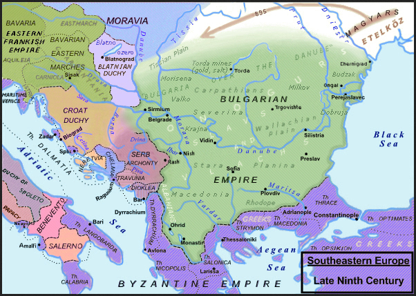
English: Southeastern Europe, late 9th century. |
||
| Calendata | |||
| Fuent |
Slavistic map, derivative from File:Balkan_9_vek.png enriched with the religious minorities & corrected following: [1]; [2]; Dragan Veselinov Manchov's works (1834-1908) synthetised here: File:Bulgaria-Iván_Asen-es.svg and [3]; Roman Kovalev, (ed.), The Other Europe in the Middle Ages: Avars, Bulgars, Khazars and Cumans, Brill, pp. 151–236. ISBN 978-90-04-16389-8; H.-E. Stier (dir.) Westermann grosser Atlas zur Weltgeschichte, Braunschweig 1985, ISBN 3-14-100919-8, pp. 64, 65, 70 & 88; Francis Conte, Les Slaves, coll. Bibliothèque de l'Évolution de l'Humanité, Albin Michel, 1996, p. 91-96; P. M. Barford, The Early Slavs. Culture and Society in Early Medieval Eastern Europe, ISBN 0-8014-3977-9; John Fine, Jr., The Early Medieval Balkans, ISBN 0 472 081497; Jean W. Sedlar, East Central Europe in the Middle Ages, 1000–1500, University of Washington Press, 2011 ISBN 0-295-97291-2; D. Hupchik, The Balkans. From Constantinople to Communism; Ian Mladjov, “Trans‐Danubian Bulgaria: Reality and Fiction“, in Byzantine Studies n.s. 3, 1998 [2000], 85–128;; Victor Spinei, The Romanians and the Turkic Nomads North of the Danube Delta from the Tenth to the Mid-Thirteenth century, Koninklijke Brill 2009, ISBN 978-90-04-17536-5. |
||
| Autor | Moodylo333 | ||
| Permiso (Reutilización d'iste fichero) |
|
||
| Atras versions | File:Balkan_9_vek.png, according with the Hungarian point of view, where the Slavic principality of Blatnograd is confused with the antic Pannonia, the river Dniester is confused with the Prut river, the Aegean islands are already Genoese five centuries in advance, and the "Bulgarian lands across the Danube" (on the northern side) are minimized, with precise borders, when in reality they were often fluctuant; this area is represented without the Bulgarian control on the gold, copper and salt mines in Transylvania (also exploited on the Dacian and Roman times) and without inhabitants, because the hungarian official point of view needs that there was no population in Transylvania before the Magyars, neither Slavic nor Romance. |
![[3]](https://fr.wikipedia.org/wiki/Second_Empire_bulgare#/media/Fichier:Bulgaria-Iv%C3%A1n_Asen2-es.svg)
Licenciando
Yo, o titular d'os dreitos d'autor d'ista obra, la publico en os termins d'a siguient licencia:
| Iste fichero ye disponible baixo a licencia Creative Commons Dedicación de Dominio Publico CC0 1.0 Universal. | |
| A persona que ha asociau una obra a iste documento la cede ta o \dominio publico por meyo d'a cesión mundial d'os suyos dreitos baixo a lei de dreitos d'autor y totz os dreitos legals adchacents propios de dita, en l'ambito permitiu por lei. Puet copiar, modificar, distribuir y reproducir o treballo, mesmo con obchectivos comercials, sin que calga pedir aprebación de l'autor.
|
Historial d'o fichero
Punche en una calendata/hora ta veyer o fichero como amaneixeba por ixas envueltas.
| Calendata/Hora | Miniatura | Dimensions | Usuario | Comentario | |
|---|---|---|---|---|---|
| actual | 09:41 30 avi 2023 | | 602 × 429 (365 kB) | Moodylo333 | Uploaded own work with UploadWizard |
Uso d'o fichero
A pachina siguient emplega iste fichero:
Uso de fichers globals
Os siguients wikis fan servir iste fichero:
- Uso en el.wikipedia.org
- Uso en fr.wikipedia.org
- Histoire de la Slovénie
- Višeslav (prince serbe)
- Pribina
- Premier Empire bulgare
- Irrédentisme bulgare
- Siège de Raguse (866-868)
- Guerres byzantino-bulgares
- Traité byzantino-bulgare (816)
- Guerre byzantino-bulgare de 894-896
- Guerre byzantino-bulgare de 913-927
- Bulgarie au-delà du Danube
- Histoire des Balkans
- Guerres byzantino-serbes
- Histoire de la Valachie
- Uso en he.wikipedia.org