
Imachen:Nahkealehtinen kasvillisuus.png

Grandaria d'ista previsualización: 800 × 398 pixels. Atras resolucions: 320 × 159 pixels | 640 × 318 pixels | 1262 × 628 pixels.
Fichero orichinal (1262 × 628 píxels; grandaria d'o fichero: 35 kB; tipo MIME: image/png)

|
Se gosa premetir a copia, a destribución y a modificación d'iste decumento baixo d'os termins d'a licencia de decumentación libre GNU, Versión 1.2 u qualsiquier altra versión posteriorment expublicata por a Free Software Foundation; sin de seccions invariaderas (Unvariant Sections), textos de portalada (Front-Cover Texts), ni textos de contraportalada (Back-Cover Texts). S'enclui una copia d'ista licencia en anglés en l'articlo GNU Free Documentation License". |
| Iste fichero se troba baixo a licencia Creative Commons Chenerica d'Atribución/Compartir-Igual 3.0. | ||
| Atribución d'autoría: Vzb83 | ||
| ||
| Ista etiqueta de licencia fue adhibida a iste fichero como parte d'a actualización d'a licencia GFDL. |
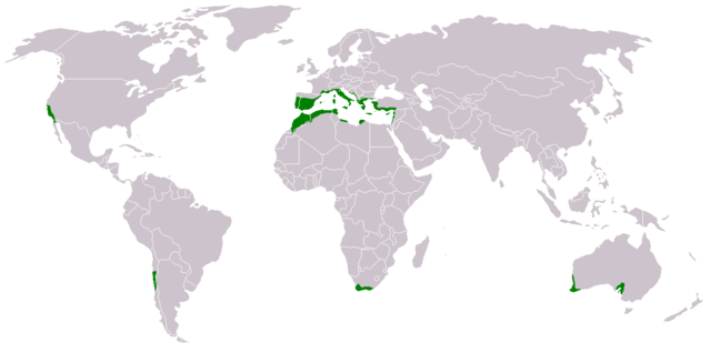
- Suomi: Nahkealehtisen eli välimerenkasvillisuuden levinneisyys.
- English: Distribution of Mediterranean forests, woodlands, and shrub biome.
Based on the blank world map BlankMap-World.png.
See also Image:Medclim.png and Image:Macchia mediterranea map.jpg.
Historial d'o fichero
Punche en una calendata/hora ta veyer o fichero como amaneixeba por ixas envueltas.
| Calendata/Hora | Miniatura | Dimensions | Usuario | Comentario | |
|---|---|---|---|---|---|
| actual | 15:34 17 mar 2018 | | 1262 × 628 (35 kB) | Maphobbyist | Montenegro border |
| 02:15 9 chul 2011 |  | 1262 × 628 (44 kB) | Maphobbyist | South Sudan has become independent on July 9, 2011. Sudan and South Sudan are shown with the new international border between them. | |
| 16:48 11 chun 2010 |  | 1262 × 628 (44 kB) | Maphobbyist | Little editing | |
| 14:35 11 chun 2010 |  | 1262 × 628 (44 kB) | Maphobbyist | Syria except the Mediterranean coastal area, Jordan, South Israel, Iraq, the Black Sea coast of Turkey and the Caspian Coast of Iran do not have a Mediterranean climate. The northwest coast of Libya including Tripoli,has a Mediterranean climate. | |
| 21:43 13 feb 2007 |  | 1262 × 628 (14 kB) | Hautala | {{GFDL-user-fi|Vzb83}} * {{fi|Nahkealehtisen eli välimerenkasvillisuuden levinneisyys.}} * {{en|Distribution of Mediterranean forests, woodlands, and shrub biome.}} Based on the blank world map Image:BlankMap-World.png. See also [[:Image:Medclim |
Uso d'o fichero
As 2 pachinas emplegan iste fichero:
Uso de fichers globals
Os siguients wikis fan servir iste fichero:
- Uso en ar.wikipedia.org
- Uso en bs.wikipedia.org
- Uso en ca.wikipedia.org
- Uso en cs.wikipedia.org
- Uso en da.wikipedia.org
- Uso en eo.wikipedia.org
- Uso en eu.wikipedia.org
- Uso en fi.wikipedia.org
- Uso en hr.wikipedia.org
- Uso en ka.wikipedia.org
- Uso en no.wikipedia.org
- Uso en pt.wikipedia.org
- Uso en sh.wikipedia.org
- Uso en sr.wikipedia.org
- Uso en zh.wikipedia.org