
Imachen:Map of the Low German Dialects.svg

Tamaño de esta previsualización PNG del archivo SVG: 646 × 600 pixels. Atras resolucions: 258 × 240 pixels | 517 × 480 pixels | 827 × 768 pixels | 1103 × 1024 pixels | 2206 × 2048 pixels | 700 × 650 pixels.
Fichero orichinal (fichero SVG, nominalment 700 × 650 píxels, grandaria: 246 kB)
| Descripción |
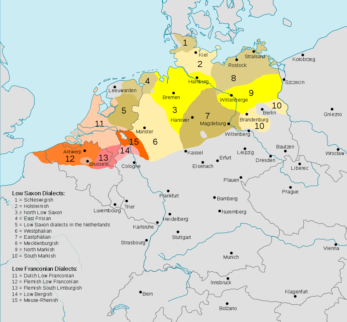
Deutsch: Darstellungskarte der niederdeutschen Mundarten (im weiteren Sinne) seit 1945
English: Distribution map of the Low German (Low Franconian and Low Saxon) languages since 1945. Note however that it's bad:
|
| Calendata | (UTC) |
| Fuent | |
| Autor |
|
| Atras versions |
Cropped version without key
|


.svg)

Iste fichero se troba baixo a licencia Creative Commons Chenerica d'Atribución/Compartir-Igual 3.0.
- Ye libre:
- de compartir – de copiar, distribuir y transmitir o treballo
- de remezclar – d'adaptar o treballo
- Baixo as siguients condicions:
- atribución d'autoría – Ha d'atribuir l'autoría d'o treballo d'a traza especificada por l'autor u persona que l'haiga licenciau (pero no pas de traza que suchiera que l'autor/os autors refirma(n) u refirma(n) l'uso que faigas d'o treballo).
- compartir igual – En caso d'alterar, transformar u enamplar iste treballo, habrá de distribuir o treballo resultant solament baixo a mesma licencia u beluna equivalent.
Rechistro orichinal de carga
This image is a derivative work of the following images:
- File:Verbreitungsgebiet_der_heutigen_niederdeutschen_Mundarten.PNG licensed with PD-user-de, PD-user-w
- 2008-08-08T10:33:32Z Gruna 1 652x652 (37059 Bytes) See previous version
- 2006-04-14T17:48:45Z Vonvon 652x652 (36806 Bytes) * created on de.wikipedia.org by [[:de:Benutzer:Postmann Michael]] on 31 December 2004 * Beschreibung:Darstellungskarte der niederdeutschen Mundarten seit 1945 (''Location Map of the Low Germanic languages'') * original licen
- File:Europe.svg licensed with PD-USGov-CIA-WF
Uploaded with derivativeFX
Historial d'o fichero
Punche en una calendata/hora ta veyer o fichero como amaneixeba por ixas envueltas.
| Calendata/Hora | Miniatura | Dimensions | Usuario | Comentario | |
|---|---|---|---|---|---|
| actual | 18:54 11 avi 2017 | | 700 × 650 (246 kB) | Alphathon | Border in Lake Geneva and the Rhine delta |
| 18:24 11 avi 2017 |  | 700 × 650 (245 kB) | Alphathon | Corrected some settlement placements and Anglicised names | |
| 17:04 11 avi 2017 |  | 700 × 650 (245 kB) | Alphathon | Correction (Holland → the Netherlands) | |
| 21:54 27 oct 2015 |  | 700 × 650 (266 kB) | Alphathon | Corrected some minor errors and cropped | |
| 14:30 7 feb 2011 |  | 789 × 852 (292 kB) | Alphathon | Missed some in previous edit | |
| 14:29 7 feb 2011 |  | 789 × 852 (292 kB) | Alphathon | Minor font change (so it renders properly in previews etc.) | |
| 14:14 7 feb 2011 |  | 789 × 852 (290 kB) | Alphathon | Translated into English since it has an English title. German Version will be re-uploaded under a different name | |
| 01:15 7 feb 2011 |  | 789 × 852 (285 kB) | Alphathon | {{Information |Description={{de|Darstellungskarte der niederdeutschen Mundarten seit 1945}} {{en|Distribution map of the Low Saxon and Low Franconian languages since 1945}} |Source=*File:Verbreitungsgebiet_der_heutigen_niederdeutschen_Mundarten.PNG |
Uso d'o fichero
A pachina siguient emplega iste fichero:
Uso de fichers globals
Os siguients wikis fan servir iste fichero:
- Uso en ar.wikipedia.org
- Uso en en.wikipedia.org
- Uso en en.wikivoyage.org
- Uso en nds-nl.wikipedia.org
- Uso en nl.wikipedia.org
- Uso en ru.wikipedia.org
- Uso en simple.wikipedia.org
- Uso en zh.wikivoyage.org