Ir al contenido

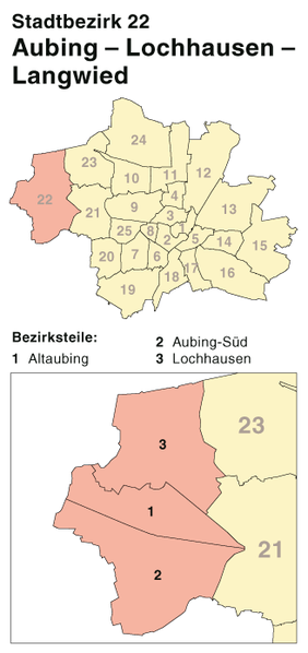
Imachen:München - Stadtbezirk 22 (Karte) - Aubing - Lochhausen - Langwied.png

Contenido de la página no disponible en otros idiomas.
De Biquipedia

Fichero orichinal (328 × 696 píxels; grandaria d'o fichero: 40 kB; tipo MIME: image/png)

Iste fichero ye de Wikimedia Commons y pueden emplegar-lo atros prochectos. Debaixo s'amuestra a descripción d'a suya pachina de descripción.

Descripción
Deutsch: Kartenserie der Münchner Stadtbezirke
English: Boroughs of Munich map series
Calendata
Fuent Self made, created with Adobe Illustrator 12.0
Autor Maximilian Dörrbecker (Chumwa)
Permiso
(Reutilización d'iste fichero)

This map was created by Maximilian Dörrbecker. Attribution to Wikipedia or another project of the Wikimedia foundation is required if it is used outside of projects of the Wikimedia foundation.

w:an:Creative Commons
atribución d'autoría compartir igual
Iste fichero se troba baixo a licencia Creative Commons Chenerica d'Atribución/Compartir-Igual 2.5.
Ye libre:
  • de compartir – de copiar, distribuir y transmitir o treballo
  • de remezclar – d'adaptar o treballo
Baixo as siguients condicions:
  • atribución d'autoría – Ha d'atribuir l'autoría d'o treballo d'a traza especificada por l'autor u persona que l'haiga licenciau (pero no pas de traza que suchiera que l'autor/os autors refirma(n) u refirma(n) l'uso que faigas d'o treballo).
  • compartir igual – En caso d'alterar, transformar u enamplar iste treballo, habrá de distribuir o treballo resultant solament baixo a mesma licencia u beluna equivalent.

"I want to use the image. How do I do that?"

You can use this map freely for any purpose, including commercial use, provided that you license it under the above license. My suggestion is to use the following text:

This Wikipedia and Wikimedia Commons map is from the user Maximilian Dörrbecker (Chumwa) and is freely available at //commons.wikimedia.org/wiki/File:M%C3%BCnchen_-_Stadtbezirk_22_(Karte)_-_Aubing_-_Lochhausen_-_Langwied.png under the creative commons cc-by-sa 2.5 license.
If necessary, please translate the text in your language. For electronic use please include the links in the text as shown, for printed use please print the text as shown. If you use the image I would appreciate it if you would let me know on my talk page. If it is published it would be very kind if you could send me a backup copy as PDF file.
Atras versions

Die Serie besteht aus den folgenden Karten / The series consists of the following maps :

unterteilt nach Stadtteilen, nicht Bezirksteilen

Leyendas

Añade una explicación corta acerca de lo que representa este archivo

Elementos representados en este archivo

representa a espanyol

agosto 2007

Historial d'o fichero

Punche en una calendata/hora ta veyer o fichero como amaneixeba por ixas envueltas.

Calendata/HoraMiniaturaDimensionsUsuarioComentario
actual07:55 31 oct 2010Miniatura d'a versión de 07:55 31 oct 2010328 × 696 (40 kB)BjsReverted to version as of 16:16, 18 August 2007, war schon richtig, Stadtteile/viertel und Bezirksteile/viertel sind verschiedene Unterteileungen, die nicht verwechselt werden sollten
15:56 17 may 2010Miniatura d'a versión de 15:56 17 may 2010328 × 696 (44 kB)Dietzel65Korrekturen: Aubing-Süd existiert nicht als Stadtteilbeizeichnung. Langwied hat in der Legende gefehlt.
16:16 18 ago 2007Miniatura d'a versión de 16:16 18 ago 2007328 × 696 (40 kB)Chumwa{{Information |Description= *{{ de }} Kartenserie der Münchner Stadtbezirke *{{ en }} Boroughs of Munich map series |Source=Self made, created with Adobe Illustrator 12.0 |Date=August 2007 |Author=Maximilian Dörrbecker ([[:de:User:Ch

A pachina siguient emplega iste fichero:

Uso de fichers globals

Os siguients wikis fan servir iste fichero: