
Imachen:LocationSouthAfrica-1990.png
No bi ha garra versión con resolución más gran.
LocationSouthAfrica-1990.png (250 × 115 píxels; grandaria d'o fichero: 5 kB; tipo MIME: image/png)

|
File:South Africa in its region (1990).svg es una versión vectorial de este archivo. Debería usarse esa versión en lugar de este archivo PNG, cuando sea mejor.
File:LocationSouthAfrica-1990.png → File:South Africa in its region (1990).svg
Para más información, lee Ayuda:SVG. |
.svg) |
Resumen
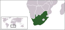
A locator map of South Africa showing en:Walvis Bay. This locator map is intended for South African articles taking place before the transfer of Walvis Bay to Namibia in 1994. The orginal map is by Vardion. Since that map is PD, this one is well.
Licenciando
| Iste treballo ha estau liberau a o dominio publico por o suyo autor, Hoshie. Isto aplica en tot o mundo. En qualques países isto podría no ser legalment posible; si ixo ocurrise: |
Historial d'o fichero
Punche en una calendata/hora ta veyer o fichero como amaneixeba por ixas envueltas.
| Calendata/Hora | Miniatura | Dimensions | Usuario | Comentario | |
|---|---|---|---|---|---|
| actual | 07:26 17 avi 2009 | | 250 × 115 (5 kB) | Hoshie | Reverted to version as of 03:34, 16 August 2006 rv, Nambia itself wasn't a part of S. Africa |
| 18:37 2 avi 2008 |  | 250 × 115 (5 kB) | ChrisDHDR | South Africa included Namibia at the time | |
| 03:34 16 ago 2006 |  | 250 × 115 (5 kB) | Hoshie | == Summary == A locator map of South Africa showing en:Walvis Bay. This locator map is intended for South African articles taking place before the transfer of Walvis Bay to Nambia in 1994. The orginal map is by [[Us |
Uso d'o fichero
Garra pachina tiene un vinclo ta iste fichero.