Imachen:Kingdoms of Israel and Judah map 830.svg

Contenido de la página no disponible en otros idiomas.
De Biquipedia

Fichero orichinal(fichero SVG, nominalment 720 × 859 píxels, grandaria: 96 kB)

Renderizar esta imagen en .

Iste fichero ye de Wikimedia Commons y pueden emplegar-lo atros prochectos. Debaixo s'amuestra a descripción d'a suya pachina de descripción.

Descripción
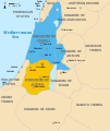
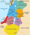
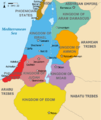
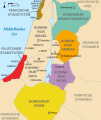
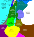
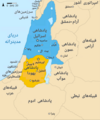
English: Approximate map showing the Kingdoms of Israel (blue) and Judah (orange), ancient Southern Levant borders and ancient cities such as Urmomium and Jerash. The map shows the region in the 9th century BCE.
Italiano: Il regno di Giuda e quello di Israele nell'età del ferro (VIII secolo a.C.).
日本語: 紀元前830年代のユダ王国(黄色).
Русский: Царство Иудея 927 по 526 гг. до н. э. Отсюда иудеи были сосланы завоевателями в Вавилонский регион.
Bahasa Indonesia: Peta kerajaan-kerajaan di daerah tersebut pada abad 9 SM.
Simple English: The northern Kingdom of Israel and the Kingdom of Judah to the south.
Srpskohrvatski / српскохрватски: Karta Sjevernog i JUžnog Kraljevstva. Samarija je bila glavni grad Kraljevstva Izrael (plavo). 830-e pne.,.
Latviešu: Izraēlas un Jūdejas karalistes. Jūdejas karaliste (dzeltenā) ap 830. gadu p.m.ē.
Calendata (UTC)
Fuent http://www.jewishvirtuallibrary.org/map-of-israel-and-judah-733-bce
Autor
Atras versions

[editar]

Color scheme 1
Color scheme 2
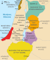
Israel and Judah colored
Just Israel and Judah
Yo, titular d'os dreitos d'autor d'ista obra, la publico en os termins d'as siguients licencias:
w:an:Creative Commons
atribución d'autoría compartir igual
Iste fichero se troba baixo a licencia Creative Commons Chenerica d'Atribución/Compartir-Igual 3.0.
Ye libre:
  • de compartir – de copiar, distribuir y transmitir o treballo
  • de remezclar – d'adaptar o treballo
Baixo as siguients condicions:
  • atribución d'autoría – Ha d'atribuir l'autoría d'o treballo d'a traza especificada por l'autor u persona que l'haiga licenciau (pero no pas de traza que suchiera que l'autor/os autors refirma(n) u refirma(n) l'uso que faigas d'o treballo).
  • compartir igual – En caso d'alterar, transformar u enamplar iste treballo, habrá de distribuir o treballo resultant solament baixo a mesma licencia u beluna equivalent.
GNU head Se gosa premetir a copia, a destribución y a modificación d'iste decumento baixo d'os termins d'a licencia de decumentación libre GNU, Versión 1.2 u qualsiquier altra versión posteriorment expublicata por a Free Software Foundation; sin de seccions invariaderas (Unvariant Sections), textos de portalada (Front-Cover Texts), ni textos de contraportalada (Back-Cover Texts). S'enclui una copia d'ista licencia en anglés en l'articlo GNU Free Documentation License".
Vusté puet utilizar a licencia que s'estime mas.

Rechistro orichinal de carga

This image is a derivative work of the following images:

  • File:Oldtidens_Israel_&_Judea.svg licensed with Cc-by-sa-3.0, GFDL
    • 2010-01-30T16:10:36Z FinnWikiNo 726x868 (109641 Bytes) {{Information |Description={{en|1=Map showing the ancient levant borders and ancient cities such as [[Urmomium]] and [[Jerash]]. The map also shows the region in the 9th century BCE. Notice the coastal land of Philistia, from

Uploaded with derivativeFX

Leyendas

Añade una explicación corta acerca de lo que representa este archivo

Elementos representados en este archivo

representa a espanyol

Judá espanyol

12 chul 2010

tipo de archivo espanyol

image/svg+xml

Historial d'o fichero

Punche en una calendata/hora ta veyer o fichero como amaneixeba por ixas envueltas.

Calendata/HoraMiniaturaDimensionsUsuarioComentario
actual14:12 1 oct 2021Miniatura d'a versión de 14:12 1 oct 2021720 × 859 (96 kB)SadopaulFile uploaded using svgtranslate tool (https://svgtranslate.toolforge.org/). Added translation for ko.
15:50 10 feb 2017Miniatura d'a versión de 15:50 10 feb 2017720 × 859 (80 kB)Malus Catulusremoved 'Sizu' - a weird artifact from the Norse original
23:48 12 feb 2011Miniatura d'a versión de 23:48 12 feb 2011720 × 859 (78 kB)Malus Catulus-
11:29 13 chul 2010Miniatura d'a versión de 11:29 13 chul 2010720 × 859 (79 kB)Malus CatulusFixed Judah color
10:51 13 chul 2010Miniatura d'a versión de 10:51 13 chul 2010720 × 859 (79 kB)Malus CatulusAdded colors for the two kingdoms and converted their text to path and arial
23:53 12 chul 2010Miniatura d'a versión de 23:53 12 chul 2010720 × 859 (62 kB)Malus CatulusShrinked down the borders
19:43 12 chul 2010Miniatura d'a versión de 19:43 12 chul 2010720 × 859 (62 kB)Malus Catulus{{Information |Description={{en|1=Map showing the ancient levant borders and ancient cities such as Urmomium and Jerash. The map also shows the region in the 9th century BCE. Notice the coastal land of Philistia, from which the name "Palestine

Garra pachina tiene un vinclo ta iste fichero.

Uso de fichers globals

Os siguients wikis fan servir iste fichero:

Veyer mas información sobre l'uso global d'iste fichero.

Metadatos