
Imachen:IrishSeaReliefMap.jpg
Grandaria d'ista previsualización: 415 × 600 pixels. Atras resolucions: 166 × 240 pixels | 332 × 480 pixels | 531 × 768 pixels | 1043 × 1507 pixels.
Fichero orichinal (1043 × 1507 píxels; grandaria d'o fichero: 2,15 MB; tipo MIME: image/jpeg)
Resumen
| Descripción |
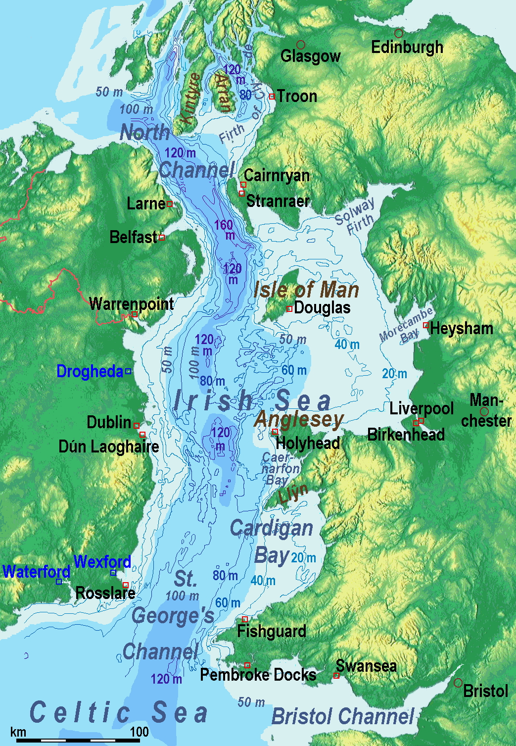
A map of the en:Irish Sea. Major ports shown with red marks. freight-only ports in blue. |
| Calendata | old map 2005-08-03; new map 2014-05-11 |
| Fuent | old map: http://www.vindaloo.uklinux.net/jjg/code/tmutils.html-> new map: Maps for Free and Treballo de qui la cargó |
| Autor | old one Users SFC9394, Seabhcan on en.wikipedia, new one Ulamm (talk) 01:37, 11 May 2014 (UTC) |
| Permiso (Reutilización d'iste fichero) |
old map: from http://www.vindaloo.uklinux.net/jjg/code/tmutils.html. Released to public domain by creator. |
| Atras versions |
History of the od map
Old map riginally from en.wikipedia; description page is (was) here
- 14:22, 20 March 2006 SFC9394 461×561 (85,860 bytes) (Corrected locations for Cairnryan & Stranraer)
- 10:56, 25 November 2005 Seabhcan 461×561 (73,292 bytes) (Removed the ports of Heysham and Fleetwood, to which en:User:Robdurbar took offence. )
- 16:23, 3 August 2005 Seabhcan 461×561 (95,162 bytes) (Added channel names)
- 15:50, 3 August 2005 Seabhcan 461×561 (93,219 bytes) (A map of the en:Irish Sea Major ports shown in red. freight only ports in blue. from [1]. Released to public domain by creator.)
Sources of information for the new map
- internal report Nr. 174 of the National Oceanography Centre (Liverpool)
- http://www.dcenr.gov.ie (Department of Communications, Energy and Natural Resources) -> IOSEA4Annex–Master–r02–Fiinal.pdf (Fourth Strategic Environmental Assessment for Oil and Gas ACtivity in Irelands Offshore Waters) -> figures 2.1 & 2.2a
Licenciando
Yo, o titular d'os dreitos d'autor d'ista obra, la publico en os termins d'a siguient licencia:
Iste fichero se troba baixo a licencia Creative Commons Chenerica d'Atribución/Compartir-Igual 3.0.
- Ye libre:
- de compartir – de copiar, distribuir y transmitir o treballo
- de remezclar – d'adaptar o treballo
- Baixo as siguients condicions:
- atribución d'autoría – Ha d'atribuir l'autoría d'o treballo d'a traza especificada por l'autor u persona que l'haiga licenciau (pero no pas de traza que suchiera que l'autor/os autors refirma(n) u refirma(n) l'uso que faigas d'o treballo).
- compartir igual – En caso d'alterar, transformar u enamplar iste treballo, habrá de distribuir o treballo resultant solament baixo a mesma licencia u beluna equivalent.
(Uploaded using CommonsHelper or PushForCommons)
Historial d'o fichero
Punche en una calendata/hora ta veyer o fichero como amaneixeba por ixas envueltas.
| Calendata/Hora | Miniatura | Dimensions | Usuario | Comentario | |
|---|---|---|---|---|---|
| actual | 11:42 13 may 2014 | | 1043 × 1507 (2,15 MB) | Ulamm | optimized colour scale |
| 14:17 12 may 2014 |  | 1043 × 1507 (1,87 MB) | Ulamm | more names, smaller letters | |
| 12:25 11 may 2014 |  | 1043 × 1449 (1,73 MB) | Ulamm | depths and names of bays and inlets | |
| 10:56 11 may 2014 |  | 1043 × 1449 (1,71 MB) | Ulamm | land colours lightened | |
| 02:22 11 may 2014 |  | 1043 × 1449 (1,7 MB) | Ulamm | more ports | |
| 01:50 11 may 2014 |  | 1043 × 1449 (1,69 MB) | Ulamm | completion outside the Irish Sea | |
| 01:39 11 may 2014 |  | 1043 × 1449 (1,68 MB) | Ulamm | completely new map | |
| 09:01 1 nov 2006 |  | 461 × 561 (84 kB) | Korrigan | {{Information| |Description= A map of the en:Irish Sea Major ports shown in red. freight only ports in blue. |Source= |Date= |Author=Users SFC9394, Seabhcan on [http://en.wikipedia.org en.wikipedia] |Permiss |
Uso d'o fichero
A pachina siguient emplega iste fichero:
Uso de fichers globals
Os siguients wikis fan servir iste fichero:
- Uso en af.wikipedia.org
- Uso en ast.wikipedia.org
- Uso en ba.wikipedia.org
- Uso en be.wikipedia.org
- Uso en bg.wikipedia.org
- Uso en bn.wikipedia.org
- Uso en br.wikipedia.org
- Uso en ca.wikipedia.org
- Uso en cs.wikipedia.org
- Uso en cv.wikipedia.org
- Uso en cy.wikipedia.org
- Uso en da.wikipedia.org
- Uso en el.wikipedia.org
- Uso en eo.wikipedia.org
- Uso en es.wikipedia.org
- Uso en eu.wikipedia.org
- Uso en fa.wikipedia.org
- Uso en fy.wikipedia.org
- Uso en gl.wikipedia.org
- Uso en gv.wikipedia.org
- Uso en he.wikipedia.org
- Uso en hu.wikipedia.org
- Uso en hu.wiktionary.org
- Uso en id.wikipedia.org
- Uso en is.wikipedia.org
- Uso en ka.wikipedia.org
- Uso en kk.wikipedia.org
- Uso en ko.wikipedia.org
- Uso en ku.wikipedia.org
- Uso en lmo.wikipedia.org
- Uso en lt.wikipedia.org
Veyer mas información sobre l'uso global d'iste fichero.