
Imachen:EU map names isles.png
No bi ha garra versión con resolución más gran.
EU_map_names_isles.png (505 × 452 píxels; grandaria d'o fichero: 48 kB; tipo MIME: image/png)
Resumen
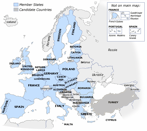
From wiki en: Based on existing Europe map. Attempt at a clearer map of the European Union and its neighbours (also candidates). Includes outlying EU member-state territories. (Only those considered part of home country). Inclusion as on Euro banknotes, but also including Cyprus. Blank version.
Licenciando

|
Se gosa premetir a copia, a destribución y a modificación d'iste decumento baixo d'os termins d'a licencia de decumentación libre GNU, Versión 1.2 u qualsiquier altra versión posteriorment expublicata por a Free Software Foundation; sin de seccions invariaderas (Unvariant Sections), textos de portalada (Front-Cover Texts), ni textos de contraportalada (Back-Cover Texts). S'enclui una copia d'ista licencia en anglés en l'articlo GNU Free Documentation License". |
| Iste fichero se troba baixo a licencia Creative Commons Chenerica d'Atribución/Compartir-Igual 3.0. | ||
| ||
| Ista etiqueta de licencia fue adhibida a iste fichero como parte d'a actualización d'a licencia GFDL. |
Historial d'o fichero
Punche en una calendata/hora ta veyer o fichero como amaneixeba por ixas envueltas.
| Calendata/Hora | Miniatura | Dimensions | Usuario | Comentario | |
|---|---|---|---|---|---|
| actual | 09:27 29 avi 2006 | | 505 × 452 (48 kB) | Palazov~commonswiki | {{Information |Description=Map of the European Union |Source= English Wikipedia |Date=n/a |Author=n/a |Permission=GFDL }} |
| 23:50 19 feb 2006 |  | 505 × 452 (45 kB) | Gabrielt4e~commonswiki | From wiki en: Based on existing Europe map. Attempt at a clearer map of the European Union and its neighbours (also candidates). Includes outlying EU member-state territories. (Only those considered part of home country). Inclusion as on Euro banknotes, b |
Uso d'o fichero
Garra pachina tiene un vinclo ta iste fichero.
Uso de fichers globals
Os siguients wikis fan servir iste fichero:
- Uso en de.wikipedia.org
- Uso en en.wikipedia.org
- Uso en hr.wikipedia.org
- Uso en pnb.wikipedia.org
- Uso en pt.wikipedia.org
- Uso en zh.wikipedia.org