
Imachen:Dioecesis Thraciae 400 AD.png
No bi ha garra versión con resolución más gran.
Dioecesis_Thraciae_400_AD.png (461 × 352 píxels; grandaria d'o fichero: 205 kB; tipo MIME: image/png)
Resumen
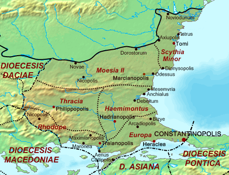
| Descripción | Map of the Diocese of Thrace (Dioecesis Thraciae) ca. 400 AD, showing the subordinate provinces and the major cities. |
| Calendata | |
| Fuent |
Base map found at en:Topographic map#Global 1-kilometer map, otherwise self-made. Data based on maps in atlases and the internet and on contemporary sources, primarily the Notitia Dignitatum. Note: The exact course of the provincial boundaries is very uncertain and in many cases only approximate. |
| Autor | Cplakidas |
Licenciando
| Yo, o titular d'os dreitos d'autor d'ista obra, lo libero en o dominio publico. Isto aplica en tot o mundo. En qualques países isto podría no ser legalment posible; si ixo ocurrise: Atorgo a qualsiquier persona o dreito d'usar iste treballo ta qualsiquier proposito, sin garra tipo de condición, fueras d'as que sían requiestas por a lei. |
Historial d'o fichero
Punche en una calendata/hora ta veyer o fichero como amaneixeba por ixas envueltas.
| Calendata/Hora | Miniatura | Dimensions | Usuario | Comentario | |
|---|---|---|---|---|---|
| actual | 14:30 20 may 2017 | | 461 × 352 (205 kB) | Julieta39 | Antic shoreline of the Danube mouths since Grigore Antipa's "Black Sea" (1940) and Andrei Nacu's paleomap [https://fr.wikipedia.org/wiki/Delta_du_Danube#/media/File:Danube_Delta_evolution.gif]. |
| 16:25 2 oct 2007 |  | 461 × 352 (139 kB) | Cplakidas | {{Information |Description=Map of the Diocese of Thrace (''Dioecesis Thraciae'') ca. 400 AD, showing the subordinate provinces and the major cities. |Source=Base map found at en:Topographic map#Global 1-kilometer map, other |
Uso d'o fichero
A pachina siguient emplega iste fichero:
Uso de fichers globals
Os siguients wikis fan servir iste fichero:
- Uso en ar.wikipedia.org
- Uso en arz.wikipedia.org
- Uso en az.wikipedia.org
- Uso en be.wikipedia.org
- Uso en bg.wikipedia.org
- Uso en ca.wikipedia.org
- Uso en cs.wikipedia.org
- Uso en da.wikipedia.org
- Uso en de.wikipedia.org
- Uso en de.wikivoyage.org
- Uso en el.wikipedia.org
- Uso en en.wikipedia.org
- Uso en es.wikipedia.org
Veyer mas información sobre l'uso global d'iste fichero.