
Imachen:Aquitani tribes map-fr.svg

Tamaño de esta previsualización PNG del archivo SVG: 702 × 600 pixels. Atras resolucions: 281 × 240 pixels | 562 × 480 pixels | 899 × 768 pixels | 1199 × 1024 pixels | 2398 × 2048 pixels | 878 × 750 pixels.
Fichero orichinal (fichero SVG, nominalment 878 × 750 píxels, grandaria: 1,26 MB)

Resumen
| Descripción |
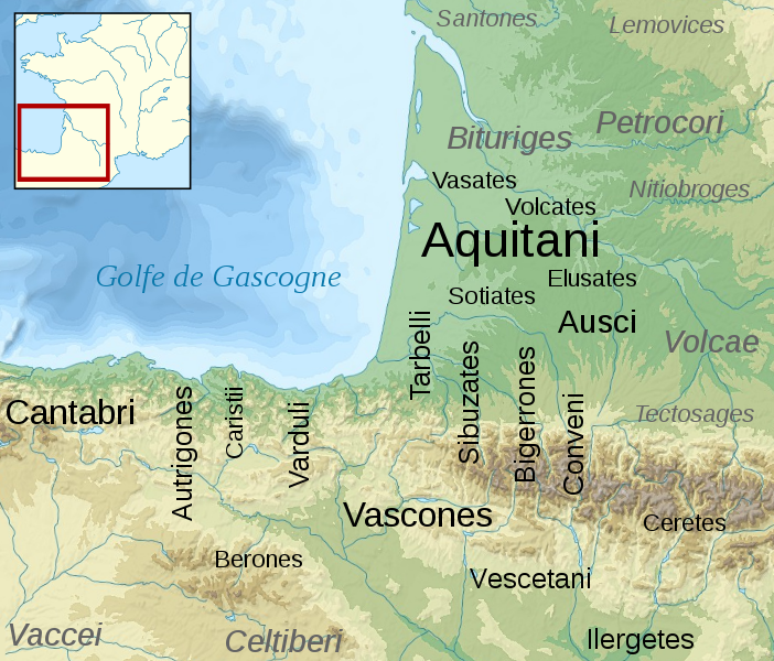
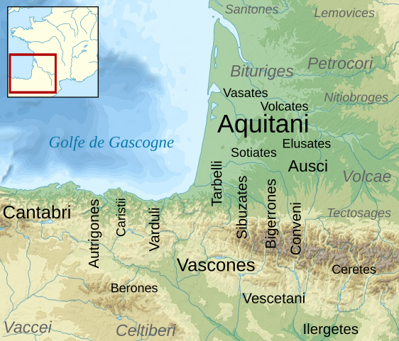
English: Map of the Aquitani and surrounding tribes in early Roman times.
Français : Carte des peuples de la Gaule Aquitaine au début de l'époque romaine.
|
||
| Calendata | |||
| Fuent |
|
||
| Autor | Sémhur | ||
| Atras versions | |||
| Atribución d'autoría (requerido por la licencia) | © Sémhur / Wikimedia Commons / | ||
| SVG | W3C-validity not checked.
|
||
| Graphic Lab |

| Posición de la cámara | | Ubicación de esta y otras imágenes en: OpenStreetMap |
|---|
Licenciando
Yo, titular d'os dreitos d'autor d'ista obra, la publico en os termins d'as siguients licencias:
| Copyleft: ista obra d'arte ye libre; puet redistribuir-la y modificar-la d'alcuerdo con os termins d'a licencia d'arte libre. Trobará un eixemplar d'ista licencia en a pachina d'o Copyleft Attitude, y tamién en atras pachinas. |
This file is licensed under the Creative Commons Attribution-Share Alike 4.0 International, 3.0 Unported, 2.5 Generic, 2.0 Generic and 1.0 Generic license.
- Ye libre:
- de compartir – de copiar, distribuir y transmitir o treballo
- de remezclar – d'adaptar o treballo
- Baixo as siguients condicions:
- atribución d'autoría – Ha d'atribuir l'autoría d'o treballo d'a traza especificada por l'autor u persona que l'haiga licenciau (pero no pas de traza que suchiera que l'autor/os autors refirma(n) u refirma(n) l'uso que faigas d'o treballo).
- compartir igual – En caso d'alterar, transformar u enamplar iste treballo, habrá de distribuir o treballo resultant solament baixo a mesma licencia u beluna equivalent.
Vusté puet utilizar a licencia que s'estime mas.
Rechistro orichinal de carga
This image is a derivative work of the following images:
- File:France_map_Lambert-93_topographic-blank.svg licensed with Cc-by-sa-3.0,2.5,2.0,1.0, GFDL
- 2008-11-13T17:24:53Z Sting 2000x1898 (1639447 Bytes) + boundary for Channel Islands ; - canals
- 2008-10-01T04:59:44Z Sting 2000x1898 (1682809 Bytes) == Summary == {{Location|46|15|00|N|02|06|00|E|scale:10000000}} {{Information |Description={{en|Blank topographic map of [[:en:France|France]] in the official Lambert-93 projection.}} {{fr|Carte topographique vierge de la [[
- File:Aquitani.gif licensed with PD-self
- 2007-01-25T14:16:29Z Michel BUZE 481x393 (10166 Bytes) {{Information |Description= *Author: [[:en:User:Sugaar|Sugaar]] *Sources: various (ultimately [[:en:Strabo]] and [[:en:Pliny]]) *Based on [[:en::Image:Basque tribes.gif]] (the only diference is that it tags the Aquitani confe
- File:Blank_map_of_Gaul_1st_century_BC.svg licensed with Cc-by-sa-2.5,2.0,1.0, GFDL
- 2007-07-07T19:30:39Z Historicair 755x784 (45078 Bytes) {{Information |Description={{fr}}Carte vierge de la Gaule au Ier siècle avant JC {{en}}Blank map of Gaul 1st century BC. |Source=[[:Image:Caesar's Campaigns in Gaul, 1st century BC.gif]] |Date=07/07/2007 |Author=~~~~ |Permis
Uploaded with derivativeFX
Historial d'o fichero
Punche en una calendata/hora ta veyer o fichero como amaneixeba por ixas envueltas.
| Calendata/Hora | Miniatura | Dimensions | Usuario | Comentario | |
|---|---|---|---|---|---|
| actual | 15:46 17 feb 2009 | | 878 × 750 (1,26 MB) | Sémhur | {{Information |Description= {{en|Map of the Aquitani and surrounding tribes in early Roman times. * Black: pre-Indoeuropean tribes. * Grey: Celtic tribes. ''Note: the macro-ethnicity of some of the tribes is disputed.''}} {{fr|Carte des peuples de la Ga |
Uso d'o fichero
A pachina siguient emplega iste fichero:
Uso de fichers globals
Os siguients wikis fan servir iste fichero:
- Uso en azb.wikipedia.org
- Uso en az.wikipedia.org
- Uso en bg.wikipedia.org
- Uso en br.wikipedia.org
- Uso en ca.wikipedia.org
- Uso en de.wikipedia.org
- Uso en el.wikipedia.org
- Uso en en.wikipedia.org
- Uso en en.wiktionary.org
- Uso en eo.wikipedia.org
- Uso en eu.wikipedia.org
- Uso en fi.wikipedia.org
- Uso en fr.wikipedia.org
Veyer mas información sobre l'uso global d'iste fichero.