Imachen:Geographic distribution of Bengali language.png

Contenido de la página no disponible en otros idiomas.
De Biquipedia

Fichero orichinal(2806 × 2080 píxels; grandaria d'o fichero: 1,36 MB; tipo MIME: image/png)

Iste fichero ye de Wikimedia Commons y pueden emplegar-lo atros prochectos. Debaixo s'amuestra a descripción d'a suya pachina de descripción.

Resumen

Descripción
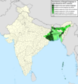
Ελληνικά: Γεωγραφική κατανομή της Βεγγαλικής Γλώσσας ανά επαρχία της Ινδίας και στο Μπανγκλαντές, τα χρώματα στις επαρχίες ποικίλουν ανάλογα με το ποσοστό ομιλητών (δεδομένα απογραφής 2011). Παράγωγο του αρχείου India district map (de-facto).svg.
English: Geographic distribution of Bengali language in India and Bangladesh. The map covers each district of India and the five shades of green show the percentage of Bengali language speakers in each district. Source: Indian census 2011. Feel free to enrich the map with data for more Indian districts, or fix any mistakes. Derivative of the file India district map (de-facto).svg.
Calendata
Fuent Treballo de qui la cargó
Autor NikosLikomitros

Licenciando

Yo, o titular d'os dreitos d'autor d'ista obra, la publico en os termins d'a siguient licencia:
w:an:Creative Commons
atribución d'autoría compartir igual
Este archivo está disponible bajo la licencia Creative Commons Attribution-Share Alike 4.0 International.
Ye libre:
  • de compartir – de copiar, distribuir y transmitir o treballo
  • de remezclar – d'adaptar o treballo
Baixo as siguients condicions:
  • atribución d'autoría – Ha d'atribuir l'autoría d'o treballo d'a traza especificada por l'autor u persona que l'haiga licenciau (pero no pas de traza que suchiera que l'autor/os autors refirma(n) u refirma(n) l'uso que faigas d'o treballo).
  • compartir igual – En caso d'alterar, transformar u enamplar iste treballo, habrá de distribuir o treballo resultant solament baixo a mesma licencia u beluna equivalent.

Leyendas

Añade una explicación corta acerca de lo que representa este archivo
Geographic distribution of Bengali language in India and Bangladesh. The map covers each district of India and the five shades of green show the percentage of Bengali language speakers in each district. Source: Indian census 2011.

Elementos representados en este archivo

representa a espanyol

creador espanyol

Algún valor sin elemento de Wikidata

licencia espanyol

CC BY-SA 4.0 espanyol

26 chun 2022

tipo de archivo espanyol

image/png

Historial d'o fichero

Punche en una calendata/hora ta veyer o fichero como amaneixeba por ixas envueltas.

Calendata/HoraMiniaturaDimensionsUsuarioComentario
actual15:05 2 chul 2022Miniatura d'a versión de 15:05 2 chul 20222806 × 2080 (1,36 MB)NikosLikomitrosA few districts of Arunachal Pradesh have a notable Bengali presence above of 1%, probably part of the Indian efforts to increase its presence in the region.
16:55 1 chul 2022Miniatura d'a versión de 16:55 1 chul 20222806 × 2080 (1,36 MB)NikosLikomitrosTwo extra fixes.
16:53 1 chul 2022Miniatura d'a versión de 16:53 1 chul 20222806 × 2080 (1,36 MB)NikosLikomitrosMinor fixes.
16:44 1 chul 2022Miniatura d'a versión de 16:44 1 chul 20222806 × 2080 (1,36 MB)NikosLikomitrosNow, this map covers all districts of India. Includes also extra information and a new colour key. The basemap is from Distribution_of_Jats_in_South_Asia.png.
21:09 26 chun 2022Miniatura d'a versión de 21:09 26 chun 20221902 × 2048 (1002 kB)NikosLikomitrosUploaded own work with UploadWizard

Garra pachina tiene un vinclo ta iste fichero.

Uso de fichers globals

Os siguients wikis fan servir iste fichero:

Metadatos