
Imachen:China prefectural-level divisions and administrative divisions (PRoC claim).png

Grandaria d'ista previsualización: 759 × 600 pixels. Atras resolucions: 304 × 240 pixels | 607 × 480 pixels | 972 × 768 pixels | 1280 × 1012 pixels | 2560 × 2023 pixels | 6246 × 4937 pixels.
Fichero orichinal (6246 × 4937 píxels; grandaria d'o fichero: 987 kB; tipo MIME: image/png)


|
The boundaries on this map show the de facto situation. This is just one of several different views on the subject (see COM:NPOV). |

|
Se espera que esta imagen sea siempre la más reciente. Siéntase libre de actualizarla cuando sea necesario.
|

|
This file may be updated to reflect new information. If you wish to use a specific version of the file without new updates being mirrored, please upload the required version as a separate file. |
Resumen
| Descripción |
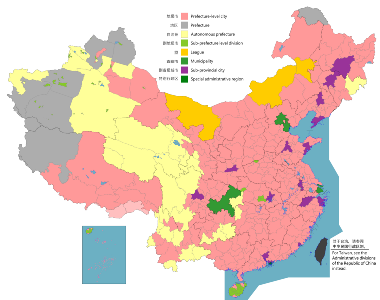
English: Map of China, shows provinces, prefecture-level divisions, etc.
日本語: 中国の地図、州、県レベルの区分などを示しています。
Русский: Карта Китая, показывает провинции, подразделения на уровне префектур и т. Д.
Монгол: Хятад улсын газрын зураг, мужууд, мужийн түвшний хэлтэс гэх мэтийг харуулсан.
中文(简体):中华人民共和国地图,显示省、地级区划等。(包含未实际控制之疆域)
中文(繁體):中華人民共和國地圖,顯示省、地級區劃等。 (包含未實際控制之疆域) |
||
| Map legend |
English:
Prefecture-level city
Prefecture
Autonomous prefecture
Sub prefecture-level division
League
Municipality
Sub-provincial city
Special administrative region 图例: 中文(简体):
地级市
地区
自治州
副地级市
盟
直辖市
副省级市
特别行政区 圖例: 中文(繁體): 地級市
地區
自治州
副地級市
盟
直轄市
副省級市
特別行政區 |
||
| Calendata |
English: File uploaded: November 6, 2021
English: Original uploaded: September 12, 2011
Latest update: 07:09, 17 November 2023 中文(简体):原始上传时间2011年9月12日
中文(繁體):文件上传时间2021年11月6日
中文(繁體):原始上傳時間2011年9月12日 |
||
| Fuent |
English: Source appearances: 中文(简体):来源于: 中文(繁體):來源於:
[]
|
||
| Creador |
|
||
| Permiso (Reutilización d'iste fichero) |
English: Map of China, administrative divisions: 中文(简体):中国地图,行政区划 中文(繁體):中國地圖,行政區劃 Yo, o titular d'os dreitos d'autor d'ista obra, la publico en os termins d'a siguient licencia:
|
||
| Geotemporal data | |||
| Fecha representada | as of February 4, 2021 | ||
| Sistema de referencia espacial | Custom | ||
| Georeferencing | |||
| Atras versions |
English: Other languages: 中文(简体):其他语言: 中文(繁體):其他語言:
[]
Derivative works on these files: |
||


.png)
_sl.png)
.png)
Licenciando
Yo, o titular d'os dreitos d'autor d'ista obra, la publico en os termins d'a siguient licencia:
Este archivo está disponible bajo la licencia Creative Commons Attribution-Share Alike 4.0 International.
- Ye libre:
- de compartir – de copiar, distribuir y transmitir o treballo
- de remezclar – d'adaptar o treballo
- Baixo as siguients condicions:
- atribución d'autoría – Ha d'atribuir l'autoría d'o treballo d'a traza especificada por l'autor u persona que l'haiga licenciau (pero no pas de traza que suchiera que l'autor/os autors refirma(n) u refirma(n) l'uso que faigas d'o treballo).
- compartir igual – En caso d'alterar, transformar u enamplar iste treballo, habrá de distribuir o treballo resultant solament baixo a mesma licencia u beluna equivalent.

|
Esta imagen debería volverse a crear como imágenes vectoriales SVG. Esto proporciona muchas ventajas, véase Commons:Media for cleanup (en inglés) para más información. Si ya hay una versión SVG de esta imagen disponible, por favor súbala a Commons. Tras subirla, reemplace esta plantilla con la plantilla
{{vector version available|nuevo nombre de imagen.svg}} en esta imagen. |
|
|
Esta imagen debería volverse a crear como imágenes vectoriales SVG. Esto proporciona muchas ventajas, véase Commons:Media for cleanup (en inglés) para más información. Si ya hay una versión SVG de esta imagen disponible, por favor súbala a Commons. Tras subirla, reemplace esta plantilla con la plantilla
{{vector version available|nuevo nombre de imagen.svg}} en esta imagen. |
| Annotations | This image is annotated: View the annotations at Commons |
Historial d'o fichero
Punche en una calendata/hora ta veyer o fichero como amaneixeba por ixas envueltas.
.png&dir=prev)
.png&offset=20220128000854)
.png&offset=&limit=20)
.png&offset=&limit=50)
.png&offset=&limit=100)
.png&offset=&limit=250)
.png&offset=&limit=500)
| Calendata/Hora | Miniatura | Dimensions | Usuario | Comentario | |
|---|---|---|---|---|---|
| actual | 02:26 11 ago 2023 | | 6246 × 4937 (987 kB) | Vikarna | 州→地区 & 副地级划分→副地级市 |
| 08:59 1 ago 2023 |  | 6246 × 4937 (987 kB) | Maanshen | Add Baiyang county-level city | |
| 09:50 1 avi 2022 |  | 6246 × 4937 (987 kB) | Maanshen | Re-added disputed borders from the third version and removed the nine-dash line to prevent future bans to maps | |
| 05:28 23 nov 2022 |  | 6246 × 4937 (951 kB) | Vikarna | municipality 市政府→直辖市 | |
| 05:10 23 nov 2022 |  | 6246 × 4937 (986 kB) | Vikarna | League 联盟→盟 | |
| 23:06 2 ago 2022 |  | 6246 × 4937 (992 kB) | Maanshen | Update disputed/claimed borders, white with stroke is not claimed and filled in color is claimed | |
| 00:08 20 abr 2022 |  | 6246 × 4937 (975 kB) | Maanshen | Fix borders between Ili's Kuytun, Huyanghe, and Karamay | |
| 03:51 1 mar 2022 |  | 6246 × 4937 (975 kB) | Maanshen | Update Shanghai land reclamation | |
| 08:26 28 chi 2022 |  | 6246 × 4937 (975 kB) | Maanshen | Fix Changchun-Siping border | |
| 00:08 28 chi 2022 |  | 6246 × 4937 (975 kB) | Maanshen | Add parts of Tiemenguan |
Uso d'o fichero
Garra pachina tiene un vinclo ta iste fichero.
Uso de fichers globals
Os siguients wikis fan servir iste fichero:
- Uso en ast.wikipedia.org
- Uso en bg.wikipedia.org
- Uso en cs.wikipedia.org
- Uso en en.wikipedia.org
- Uso en es.wikipedia.org
- Uso en fa.wikipedia.org
- Uso en fi.wikipedia.org
- Uso en fr.wikipedia.org
- Uso en hu.wiktionary.org
- Uso en id.wikipedia.org
- Uso en incubator.wikimedia.org
- Uso en ja.wikipedia.org
- Uso en pt.wikipedia.org
- Uso en ru.wikipedia.org
- Uso en sh.wikipedia.org
- Uso en si.wikipedia.org
- Uso en sv.wikipedia.org
- Uso en th.wikipedia.org
- Uso en tr.wikipedia.org
- Uso en ur.wikipedia.org
- Uso en vi.wikipedia.org
- Uso en www.wikidata.org
- Uso en wuu.wikipedia.org
- Uso en zh-yue.wikipedia.org
- Uso en zh.wikipedia.org
Veyer mas información sobre l'uso global d'iste fichero.
.png)
.png)