
Imachen:Topography of Ireland.jpg

Grandaria d'ista previsualización: 474 × 600 pixels. Atras resolucions: 190 × 240 pixels | 379 × 480 pixels | 607 × 768 pixels | 809 × 1024 pixels | 1618 × 2048 pixels | 3293 × 4168 pixels.
Fichero orichinal (3293 × 4168 píxels; grandaria d'o fichero: 3,86 MB; tipo MIME: image/jpeg)
Resumen
| Descripción |
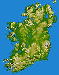
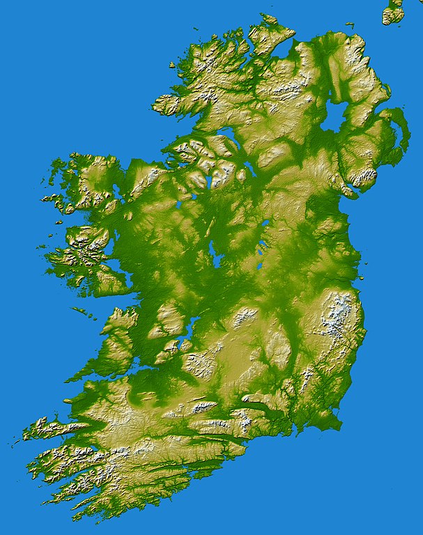
earthobservatory.nasa.gov/IOTD/view.php?id=5343 Elevation data used in this image were acquired by the Shuttle Radar Topography Mission aboard the Space Shuttle Endeavour, launched on Feb. 11, 2000. SRTM used the same radar instrument that comprised the Spaceborne Imaging Radar-C/X-Band Synthetic Aperture Radar (SIR-C/X-SAR) that flew twice on the Space Shuttle Endeavour in 1994. SRTM was designed to collect 3-D measurements of the Earth's surface. To collect the 3-D data, engineers added a 60-meter (approximately 200-foot) mast, installed additional C-band and X-band antennas, and improved tracking and navigation devices. The mission is a cooperative project between NASA, the National Geospatial-Intelligence Agency (NGA) of the U.S. Department of Defense and the German and Italian space agencies. It is managed by NASA's Jet Propulsion Laboratory, Pasadena, Calif., for NASA's Earth Science Enterprise, Washington, D.C.Topography of Ireland - Feb 2000 |
| Calendata | |
| Fuent | Flickr |
| Autor | Danny McL de Whitechapel, London, UK |
| Reviewer | File Upload Bot (Magnus Manske) |
Licenciando
Iste fichero se troba baixo a licencia Creative Commons Chenerica d'Atribución/Compartir-Igual 2.0.
- Ye libre:
- de compartir – de copiar, distribuir y transmitir o treballo
- de remezclar – d'adaptar o treballo
- Baixo as siguients condicions:
- atribución d'autoría – Ha d'atribuir l'autoría d'o treballo d'a traza especificada por l'autor u persona que l'haiga licenciau (pero no pas de traza que suchiera que l'autor/os autors refirma(n) u refirma(n) l'uso que faigas d'o treballo).
- compartir igual – En caso d'alterar, transformar u enamplar iste treballo, habrá de distribuir o treballo resultant solament baixo a mesma licencia u beluna equivalent.
| Esta imagen, originalmente subida a Flickr, fue revisada el May 31, 2010 por el administrador o revisor File Upload Bot (Magnus Manske), quien comprobó que el archivo se encontraba disponible en Flickr bajo la licencia nombrada en dicha fecha. |
Historial d'o fichero
Punche en una calendata/hora ta veyer o fichero como amaneixeba por ixas envueltas.
| Calendata/Hora | Miniatura | Dimensions | Usuario | Comentario | |
|---|---|---|---|---|---|
| actual | 07:27 31 may 2010 | | 3293 × 4168 (3,86 MB) | File Upload Bot (Magnus Manske) | {{Information |Description=[http://earthobservatory.nasa.gov/IOTD/view.php?id=5343 earthobservatory.nasa.gov/IOTD/view.php?id=5343] Elevation data used in this image were acquired by the Shuttle Radar Topography Mission aboard the Space Shuttle Endeavour |
Uso d'o fichero
A pachina siguient emplega iste fichero:
Uso de fichers globals
Os siguients wikis fan servir iste fichero:
- Uso en de.wikibooks.org
- Uso en gv.wikipedia.org
- Uso en hu.wikipedia.org
- Uso en kab.wikipedia.org